Research areas
|
Colour texture analysis |
|
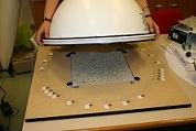
Granite grading |
|
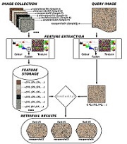
CBIR |
|
List of selected projects
- 3D Rout Modeling for FLATCity (2017-2019)
- Object-based horticultural crop under greenhouse identification using stereo imagery of WorldView-3 satellite and Landsat 8 time-series (2015-2017)
- Healthy and efficient routes in massive open-data based smart cities (2014-2016)
- Generation of very high resolution georeferenced data from GeoEye-1 and WorldView-2 satellite imagery (2011-2013)
- Advanced shop window illumination system for improved energetic efficiency (2009-2011)
- SECGO: Expert System for Ornamenthal Granite Classification (2004-2007)
- Aplication of digital image processing to visual appearance characterization of ornamenthal granite (2001-2002)
- Development of novel techniques for the colorimetric characterization of industrial materials and products (2000)


